Pinto Basin Sand Dunes / Turkey Flats
Note: There are clickable links in this post and click pictures to enlarge. My first trek of 2023! Not having hiked since the Fall of last year, I needed an easy, flat trail to get back into shape. I chose this area of the Park because the crowds are a lot less and after I read an article about this being one of the quietest parts of the Park. Well, that's for me!
After leaving my home in Escondido around 7:00 am and a quick gas fillup in Indio, I arrived at the Park's southern entrance at 9:45 am. I could already see a steady stream of vehicles pass by me as I stopped for the obligatory picture at the "sign". Earlier this month (January) we had several large atmospheric rivers of rain hit California (especially up north!) and I was hoping to see some flower blooms out here... And there was, not a lot mind you, it's still winter.
 |
| The obligatory picture by the sign |
I arrived at the small parking lot at the trailhead at 10:30 am, finished my coffee, and geared up. Of course, I walked 50 yards out before realizing I forgot my trekking poles, so back to the Jeep. Then, after about 100 yards, I realized I forgot my $500 camera on the hood of my Jeep! Back again! I always get in such a hurry and excited! About a half hour in I realized I didn't put any sunscreen on! Do'h!
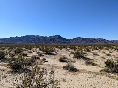
When I start out on any hike, I always look for landmarks to guide me and keep a mental picture of where I am. Looking at the direction of the sand dunes, I could see Pinto Mountain at 3,983 feet just beyond them.
 |
| Turkey Flats signage |
 |
| Pinto Mountain 3,983' |
This may look pretty flat and dull to most people, but there is plenty to see if you just look. I saw many animal tracks and small birds among the Creosote fields on Turkey Flats. How did Turkey Flats get its name? See the article here.
 |
| "Take Only Memories - Leave Only Footprints" A16 motto |
 |
| Coyote? |
 |
| Looking back to get a reference point |
 |
| A Rabbit's home |
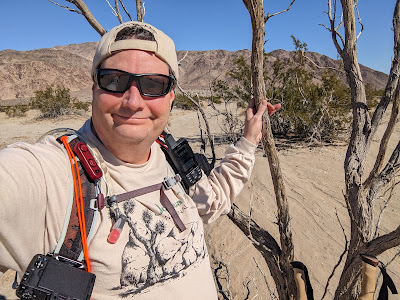
 |
| Selfie time |
 |
| Creosote roots |
 |
| More tracks |
 |
| Tracks with tail? |
 |
| Cracked desert floor after rains |
 |
| Shadow Man |
After trekking for about 45 minutes I reached the dunes. Not the typical smooth dunes you see in Death Valley or Glamis. They were covered in plants and grasses with Lizard tracks dotting the sand.
 |
| Sand dunes |
 |
| Sand dunes |
 |
| Rocky outcrop past the dunes |
After cresting the small hill, I set my eyes on a wash just beneath a rocky outcrop. I came down into it and in a bend in the wash, I saw what appeared to be stone circles. No visible evidence of fire in the middle of them. Could these be the ancient Native American Sleeping Circles? Or, are they just kids having fun? Who knows?
 |
| Rock circle |
 |
| Iron bar near rock circle |
 |
| Smaller rock circle |
 |
| Larger rock circle |
After meandering through the two hills and continuing to follow the wash, I saw my first and only Desert Sand Verbena, and a little further down some Coyote Melons. This is only the second time I've seen Coyote Mellons.
 |
| Desert Verbena |
 |
| Coyote Melons |
 |
| Coyote Melon |
After walking down the middle of the wash, I finally got to the base of the large Bajada at the base of Pinto Mountain. This was my turnaround point and a quick 10-minute snack and rest. A saw several large Smoke Trees that were dead, but a little further up I saw two healthy ones.
 |
| Pinto Wash |
 |
| Bajada |
 |
| Healthy Smoke Tree |
 |
| Snack time at the Bajada |
On the way back I noticed my feet and upper thighs begin to hurt. At least my back didn't give me any problems. I crossed a large Creosote area with hundreds of Rabbit homes dotting the area. I tried not to step near them because you can quickly collapse the tunnels underneath. I don't want to disrupt the animals' lives, not to mention a twisted ankle!
Then, in the middle of this area... a lone Silver Cholla -- all by itself. How did it get here? A bird dropping seeds? More info about how plants spread out here.
 |
| A lone Silver Cholla |
 |
| Silver Cholla |
On the way back over the dunes and back onto the Creosote fields I didn't take hardly any more pictures. Just focused on returning. After returning to the packed little parking lot and seeing people looking into the distance of the dunes, and thinking, "They should go out there and experience it up close!"
Some specs...
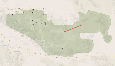 |
| Location in relativity to Park Boundaries |
 |
| My drive to the Park |
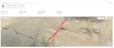 |
| Actual trek using my Garmin GPS |
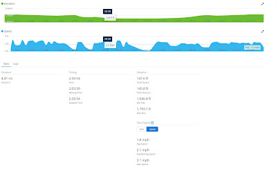 |
| Trek specs from Garmin GPS |
Below is my new logo designed by my friend Nicole Dornsife | Thornwolf
Check out her work!


Beautiful photos, Paul. I enjoyed trekking with you!
ReplyDelete